
| Cycle through labels: |
|
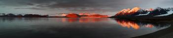
| Grimaldtoppen 802m |
| Ny Alesund Airport |
| Kongsfjorden |
| Blomstrandhalvoya isle |
| Bratiekollen 383m |
| Feiringfjellet 1054m |
| Ny Alesund Port |
| Gasoline station |
| Marraskallen 1195m |
| Italian C.N.R. Base "Dirigibile Italia" |
| German Base |
| Norway Station |
| French Station |
| Main Building |
| Korean Station |
| Chinese Base |
| Kongsbreen Glacier |
| mast constructed for the successful flight of the NORGE dirigible and the ill-fated flight of the ITALIA dirigible |
| Exilfielet 1070m |
| Kongsbreen Glacier |
| Svea (Tre Kronor) 1232m |
| Nora (Tre Kronor) 1225m |
| Collethogda 610m |
| Dana (Tre Kronor) |
| Nielsenfjellet 878m |
| Haavimbfjellet |
Canon EOS 500D - Canon 55-250mm IS.
20 photo stitch, F11, 1/400 sec, 100mm, ISO 100 This panorama is taken from the roof of the Gruvenbadet Laboratory, 1 km far from Ny Alesund, Svalbard. |
||||||||||||||||
|
|||||||


Comments
Can You give us any explanations to the glaciers.
That is the Kongsbreen Glacier. During winter all the Kongsfjord is iced, the pack it start to melt during spring. All the glaciers here are reducing the dimensions, I was to a seminar few days ago where an English researcher told they measured 10m of reduction, yearly.
Leave a comment