
| Durchlauf: |
|
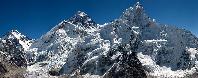
| Maly Kiezmarski Szczyt / Weberspitze (2513 m) |
| Kiezmarski / Kesmarker Spitze (2558 m) |
| Wschodni Szczyt Widel / Östliche Gabelspitze |
| Wielki Szczyt Widel / Grosse Gabelspitze (2522 m) |
| Przelecz w Widlach / Gabelscharte (2413 m) |
| Zachodni Szczyt Widel / Westliche Gabelspitze |
| Jastrzebia Turnia / Karfunkelturm (2137 m) |
| Lomnica / Lomnitzer Spitze (2634 m) |
| Mala Poslednia Turniczka / Chmielowskiturm |
| Poslednia Turnia / Jordánspitze |
| Durny Szczyt / Schwalbenturm (2623 m) |
| Durna Igla / Däumling |
| Maly Durny / Téryspitze (2592 m) |
| Czubata Turnia / Egenhofferspitze |
| Sepia Turnia / Chmielowskispitze |
| Pieciostawianska Turnia / Fünfseenspitze |
| Juhaska Turnia / Jolánspitze |
| Spiska Igla |
| Spiska Grzeda / Déryspitze (2481 m) |
| Barania Przelecz / Téry-Scharte (2393 m) |
| Czarny Szczyt / Papirusspitze (2434 m) |
| Baranie Rogi / Grüne See Spitze (2526 m) |
| Wyzni Barani Zwornik |
| Kolowy Szczyt / Rote See Spitze (2418 m) |
| Lodowy Szczyt / Eistaler Spitze (2627 m) |
| Wielka Kapalkowa Turnia / Großer Eistaler Turm (2387 m) |
| Posrednia Kapalkowa Turnia / Mittlerer Eistaler Turm |
| Zachodnie Zelazne Wrota / Westliches Eisernes Tor (2280 m) |
| Zachodni Szczyt Zelaznych Wrót / Westliche Eisernetorspitze (2360 m) |
| Zlobisty Szczyt / Martaspitze (2426 m) |
| Rumanowy Szczyt / Rumanspitze (2428 m) |
| Ganek (2462 m) |
| Wysoka / Tatra Spitze (2547 m) |
| Waga / Hunfalvy-Joch (2337 m) |
| Rysy / Meeraug Spitze (2503 m) |
| Niznie Rysy / Dénesspitze (2430 m) |
| Krywan / Krummhorn (2494 m) |
| Mieguszowiecki Czarny / Östliche Mengsdorfer Spitze (2410 m) |
| Mieguszowiecki Posredni / Mittlere Mengsdorfer Spitze (2393 m) |
| Mieguszowiecki Wielki / Große Mengsdorfer Spitze (2438 m) |
| Cubryna / Cubrina (2376 m) |
| Szeroka Jaworzynska / Schiroka (2210 m) |
| Miedziane (2233 m) |
| Bystra (2248 m) |
| Kopa (2030 m) |
| Opalony Wierch (2115 m) |
| Zólta Czuba / Gelbe Kuppe (1941 m) |
| Kozi Wierch / Gemsenberg (2291 m) |
| Swinica / Swinnica (2301 m) |
| Granaty / Granatenspitzen (2240 m) |
| Waksmundzki Wierch (2186 m) |
| Wielka Koszysta (2193 m) |
| Bielovodská dolina / Dolina Bialej Wody / Weißwassertal |
| Kolowa Dolina / Rundseetal |
| Javorová dolina / Jaworowa Dolina / Ahorntal [Uhrngärtner Grund] |
| Dolina Bialki |
| Lysa Polana |
| Javoriná |
| Zadné Med'odoly / Zadnie Koperszady / Hintere Kupferschächte |
| Muran (1890 m) |
| Nowy Wierch / Höhlenberg (2009 m) |
| Hawrania Przelecz / Rabensteinsattel (1919 m) |
| Hawran / Rabenstein (2152 m) |
| Strzystarska Przelecz (1969 m) |
| Placzliwa Skala / Greiner (2142 m) |
| Szeroka Przelecz Bielska / Breiter Sattel (1826 m) |
| Szalony Wierch / Thörichter Gern (2061 m) |
| Szalona Przelecz (1933 m) |
| Kopské sedlo / Przelecz pod Kopa / Kopasattel (1749 m) |
| Zadnie Jatki (2020 m) |
| Przednie Koperszady / Vordere Kupferschächte |
Stitched using Hugin (24 shots).
Polish and German names only. Sorry!
Gefällt
11 Mal
|
||||||||||||||||
|
|||||||


Kommentare
Thanks & best regards, RR
PS By the way, what is third different language here? Is there a difference between eg Weißseespitze (new? German) and Weisse See Spitze (old? German)?
Das Panorama gefällt mir auch sehr gut, nicht nur wegen der kompakten Übersicht der Hohen Tatra sondern auch, weil die Weiße Tatra (Belianske Tatry) so schön wiedergegeben ist. Zwischen beiden sieht man gut die Verzweigung der beiden Täler Javorova dolina und Zadne Medodoly (Hintere Kupferschächte). Leider kann ich keine Eintragungen machen, da Du die öffentliche Beschriftung gesperrt hast.
Die Beschriftung, die Du gemacht hast, ist ja sehr ausführlich und es ist wohl auch alles richtig bezeichnet - nur, daß Du nicht die slowakischen Namen angegeben hast, das kann ich nicht gut heißen. Am meisten schmerzt es mich, daß die Zdiarska vidla, der Höchste der Belianske Tatry, nicht seinen jetzigen Namen hat.
Die deutschsprachigen Namen kenne ich nur aus einem Baedecker von 1907 über "Oesterreich-Ungarn".
-------
I like very much the panorama also because the Belianske Tatry is so beautiful presented.
The caption that you did, is very detailed. I mean it is not good that you have not entered the Slovak names. The most it pains me that the Zdiarska vidla has not its current name. I know the German names only from a Baedecker of 1907 about "Austria-Hungary". Between the two world wars, the German names were not used in Czechoslovakia.
Thank you for nice rating.
Best regards, RR
PS You can look at that:
http://www.summitpost.org/diarska-vidla-pla-liv-skala/589567
despite of errors in Polish and Slovakian names.
As a matter of fact, 'Greiner', the German name of Placliva skala, is dating from the 17th century (as 'Greuner').
Szczyt is Polish and also Turnia ecc..
E. g. here are only the names Jasztrzebia Turnia / Karfunkelturm but not the Slovak Jastrabia veza. Particularly evident in Durny Szczyt / Schwalbenturm. The slovak name is Pisný stit .. so on and so on.
RRady, I had friends in Kezmarok, Zipser Germans, and we have used the German names. But first you have to accept the official name of the country.
Thanks for the note on summitpost. There is: "diarska Vidla ... This peak is also commonly named Placlivá skala (Placzliwa Skala in Polish)". You used only the Polish name. Why?
It's a banal remark the Tatra Montains were, for the historical reasons, well described in four languages. Polish is one of them! I accept the official names of Slovakia but fortunately(!) I don't have to use official forms!
For example: look at the panorama linked below.
http://www.panorama-photo.net/panorama.php?pid=14307&srch=everest
Why didn't you propose to change Everest name into (no doubt more official) Chinese or Nepalese sound?
The simple reason why I used the Polish names is: 'cause they exist.
I'm afraid I'll still use Polish names! :)
Kommentar schreiben