|
Huaylas is a name unknown to the vast majority of people, and those who know it, typically do so because the valley of Huaraz, Carhuaz and Caraz takes on the name "Callejón de Huaylas". That is, the name is given not by the major cities, but by an unknown village hidden higher up, on the last flat spot under the Cordillera Negra. (The other Cordillera, as can be seen in the picture, does not really offer flat spots at all).
The same happens on the opposite side of the Cordillera Blanca, a region mostly known as Conchucos. Here, the most important town is by far Chavín, home of the temple which marked the centre of the Chavín civilization (900 BCE - 200 BCE). People walked for hundreds of kms to visit the temple and worship the powerful and mysterious statue called Lanzón, which can be still visited in an underground chamber.
But the name of the town is Chavín de Huántar, where Huántar is a town hidden, exactly like Huaylas, on the last flat spot below the mountains. Huántar is a spot even more blessed and dreamy than Huaylas, and likewise ignored by tourist routes.
I developed a strong desire to visit Huaylas, after seeing it gently resting on its slopes, during the descent from the Alpamayo trek. That time I was on foot, coming from Conchucos and going back to Conchucos. Here I was by bicycle, I had just completed the Huascáran circuit (Huaylas - Conchucos via Punta Olimpica, and Conchucos - Huaylas via Llanganuco) and I had few days available. From Caraz, 2200 m, I had to choose between Laguna Parón, at 4500 m (but via dirt road presumably full of 4WDs producing wild clouds of dust), Punta Winchus at 4300 m (a pass similar to Punta Callán, see N.26074, but filled with Puya Raymondii, see N.26336), or Huaylas, at only 2700 m. But I chose Huaylas, also because this gave me the opportunity of a combination with the famous (because of its 36 tunnels) Cañon del Pato, where at certain spots the rocks of the two cordilleras, Blanca and Negra, nearly touch, separated by a few metres.
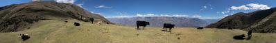
Here I am cycling up the gentle, but never-ending dirt road to Huaylas: I guess that the asphalted ascent to the 1600 m higher Punta Winchus would have been physically less demanding! At this point, I am right in front of the impressive gorge Quebrada de los Cedros. But the highlight of this picture is impossible to guess at sight. Its name is Auquispuqio, a mysterious stronghold at 3800 m on the northern flank of the Quebrada, and a place which seems to be unknown also to the web. From Wishcash, on the other side of the gorge, one clearly sees its terraces and remains, but wonders where the access can lie. The Alpenverain Karte Cordillera Blanca Nord shows a dim path abruptly climbing from 1800 m to 3800 m. Now (yes, I know, with a little delay) I am examining the pictures that I took, of course not only this panorama, but also some telephoto, and I am starting to recognize some switchbacks, at least in the lower stretch. But where does the path start? At the point (called Bocatoma) where the Río Alpamayo flows into the Río Santa the latter seems to be impassable (also to carry out this research I choose to go for Huaylas-Pato). So, I am starting to believe that one has to take literally what the Alpenverein Karte shows: from Hualcayán, 3140 m, you have to descend (I am beginning to spot some evidence of a path in some other telephoto) to the end of the Quebrada de los Cedros, 1800 m, and from there climb to Auquispuqio.
An alternative access can only be guessed in this picture. Above the wild Cedros gorge, at the beginning of the more relaxed valley that follows, there is the little village of Pueblo Alpamayo, no more than a handful of huts. The mountain to which it gives name is far more famous. The pueblo lies at 3900 m, and from there both the few inhabitants and the trekkers, to go for the civilization (and for some shop) have to cross two consecutive high passes, Vientunan (4770 m) and Osoruri (4860). From there one descends to Laguna Cullicocha (at 4500 not only a spectacular place, but also another important archelogical spot) and to Hualcayán, 3140 m. While trekkers do this in two days, villagers of Alpamayo are said to do, in the same time, the return tour. I believe this, since near the Vientunan I met a caravan and with their fully-loaded mules they moved really fast.
From Pueblo Alpamayo there is also a little-known path climbing to an unnamed pass at 4680 m and then traversing to the mysterious Quebrada Quitaracsa. Well - while climbing to Vientunan I believed to recognize a very faint path forking in direction Auquispuqio.
A local guide that I met twice in my Alpamayo - Santa Cruz loop (he was leading clockwise a group from Mallorca, while I was proceeding counterclockwise) confirmed the existence of this path. Flat for most of the time, and then ending in a steep and dangerous descent to Auquispuqio, but he did not know whether a rope is required to pass.
These are the two accesses to Auquispuquio, each one with its own unknowns. I hope one day to visit this incredible place, not as high as Yayno (4200 m, N.26108) but seemingly more difficult to reach!
Otherwise, I hope to have given sufficient elements to people wanting to take on the challenge.
The remaining of the panorama is routine. Do not compare it, of course, with N.26074, coming from a 2000 m higher Standort. However, it yields in some way a complement to that work: N.26074 shows the whole of the southern Cordillera and, where it ends, at the Nevados Huandoy, this one goes on ultil Nevado Champarà, the last white mountain of the region.
NB: this description, albeit long, actually only summarizes the one of N.27184, the twin view from the opposite side. At the time, I had more optimistic beliefs about the reachability of Auquispuquio. Now a close examination of the telephotos changed my mind...
Peter Brandt, Hans-Jörg Bäuerle, Günter Diez, J. Engelhardt, Martin Kraus, Dieter Leimkötter, Wilfried Malz, Danko Rihter, Björn Sothmann, Arjan Veldhuis, Jens Vischer, Benjamin Vogel, Alexander Von Mackensen
|
 |


Comments
Cheers, Hans-Jörg
Grüße,
Dieter
Leave a comment