|
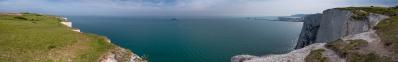
I am on the dike adjacent to Nummer Eén, a so-called 'buurtschap' near the village of Breskens. A 'buurtschap' is a small place with only a few houses but with its own name https://nl.wikipedia.org/wiki/Nummer_Een. Breskens belongs to the municipality of Sluis in the province of Zeeland.
From this point, one has a very nice view on the mouth of the river Scheldt and the North Sea as well as on the estuary more inland with the Hooge Platen, the biggest and highest plate. It is neap tide, one hour after ebb (about -1.4 m NAP) which means a moderate low water level but even so a lot of the lower sludge plates of the Hooge Platen with - I guess - a hundred thousand or more sea birds, is above water. The highest part of the plate, with the small dune belt up to +6.9 m NAP, called: 'De Bol' (58°-74°) remains dry at high tide. http://www.deltabirding.nl/hooge-platen.html
There is a big seal colony (100+ animals, 3°- 8°) on the Hooge Platen, which I knew it was there but only discovered on my pano, just below the Abbey tower Lange Jan of Middelburg. And believe it or not, I also discovered two mud nymphs just below the seals on my side of the river!
Across the 4.5 km to 9 km wide river is Walcheren peninsula. The huge 54 m NAP dune near Zoutelande, which was thought to be the highest in NL, seems to be surpassed a little by a dune north of Amsterdam. Last but not least, the point of view is maybe the best to admire the skyline of Vlissingen and Vlissingen harbor.
Next I wil upload a crop of this pano to have a better look on the seals and sea birds.
Canon Eos M6 with EF-M 18-150 mm, 35 p RAW, 122 mm (195.2 mm KB), iso 125, f 11, 1/250, PTGuiPro, 110681x3867 1.72 GB TIFF, no crop, downsizing>1900>1000>500 TIFF>sharpening>14311x500 2.5MB JPEG
Sebastian Becher, Jörg Braukmann, Hans-Jörg Bäuerle, Friedemann Dittrich, Walter Huber, Heinz Höra, Thomas Janeck, Martin Kraus, Giuseppe Marzulli, Steffen Minack, Jörg Nitz, Jan Lindgaard Rasmussen, Danko Rihter, Arne Rönsch, Björn Sothmann, Jens Vischer
|
 |


Comments
Mein Interesse war so geweckt worden, daß ich mir einige Beiträge im Internet angeschaut habe. Dabei fand ich auch diesen interessanten Beitrag: https://www.bevrijdingsmuseumzeeland.nl/index.php/de/47-articles/327-schlacht-an-der-schelde. Aber, darüber, weshalb auch die Südseite der Scheldemündung zu den Niederlanden gehört und die Grenze zu Belgien nicht in Flußmitte verläuft, habe ich nichts gefunden. Es wird wohl mit der Verlagerung der Mündung der Schelde (Westerschelde und Oosterschelde) im Laufe der letzten Jahrhunderte zu tun haben.
Concerning the mouth of the Scheldt. Both the Ooster- and WesterSchelde estuaries are geologically very young but the latter is the youngest. Old maps reveal that before the 10th century, the Westerschelde wasn't much more than a big creek and that the formation of an estuary began between 1000 -1200 and accelerated in the 14th - 15th century mainly under the influence of a number major storm floods.
https://www.vlaanderen.be/nl/publicaties/detail/de-eeuwige-schelde-ontstaan-en-ontwikkeling-van-de-schelde
Indeed Zeeuws-Vlaanderen should belong to Belgium but it is quite a complicated history. Following wikipedia link (in Dutch) describes in detail why it is not. The English and Deutsch versions are only summaries unfortunately.
Leave a comment